In this blog post, we are going to run through some simple queries to show how to query and traverse the graph. We are going to focus on the geospatial database for now. The next blog post will discuss using the Neo4j 5 Composite Database for the distributed queries.
Data Model
As a quick refresher on the data model, we have it below. We have some geospatial objects (Borough, Neighborhood, TaxiZone, Building, County and Point of Interest). Each object is connected to a HexAddress or a set of HexAddresses.

For our queries, we will run a few sample queries using Cypher as well as using the H3 plugin. Those queries will be:
- Given a latitude and longitude, find the Neighborhood and Borough
- Given a TaxiZone, how many buildings are in that TaxiZone
- What buildings are nearest a Point of Interest
Queries
Let’s get started.
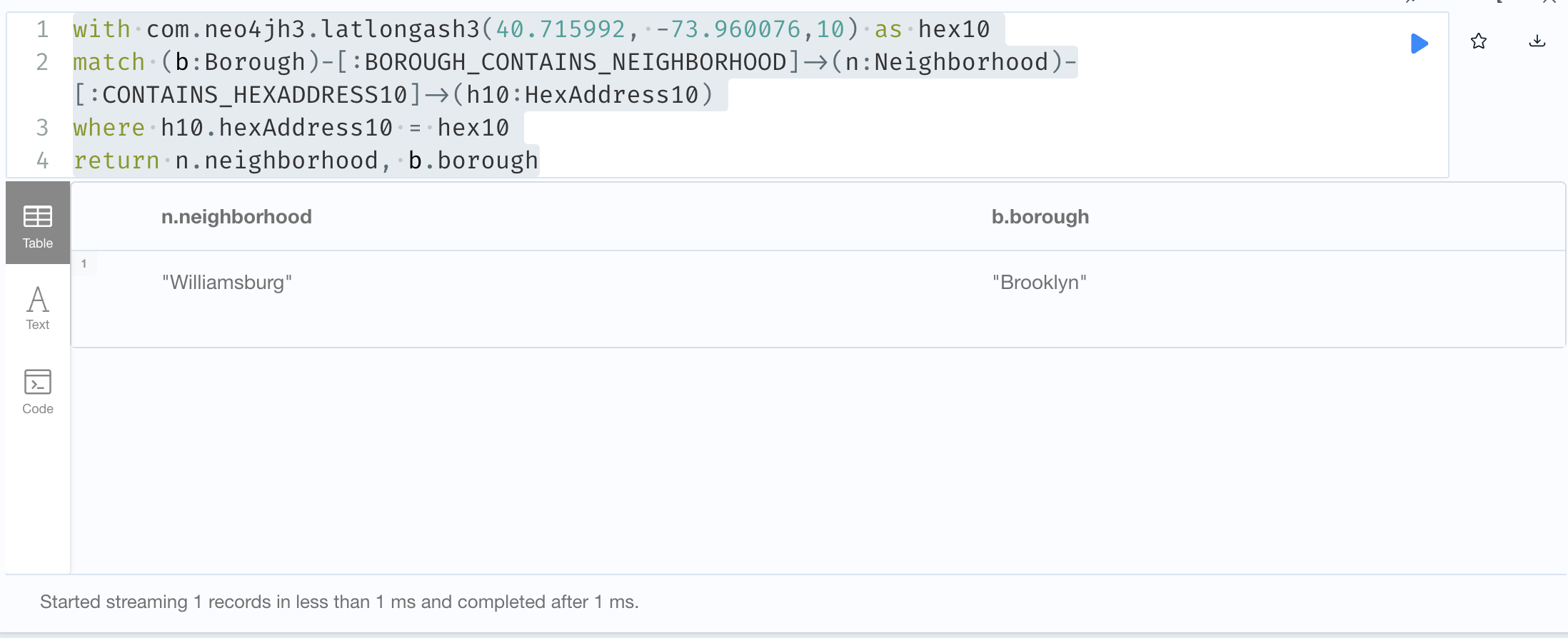
// Neighborhood and Borough for a latitude / longitude)
with com.neo4jh3.latlongash3(40.715992, -73.960076,10) as hex10
match (b:Borough)-[:BOROUGH_CONTAINS_NEIGHBORHOOD]->(n:Neighborhood)-[:CONTAINS_HEXADDRESS10]->(h10:HexAddress10)
where h10.hexAddress10 = hex10
return n.neighborhood, b.borough
In this query, we use the com.neo4jh3.latlongash3 function to convert our location to a hex10 address. We then find the Neighborhood that contains that address and traverse from the Neighborhood to the Borough. The result is;
For the next query, we will pick a TaxiZone and traverse the graph to count the number of buildings within the TaxiZone area.
// Buildings within a TaxiZone
match (tz:TaxiZone {name:'TriBeCa/Civic Center'})-[:CONTAINS_HEXADDRESS10]->(h10)-[:HAS_HEXADDRESS12]->(h12)-[:HAS_HEXADDRESS13]->(h13)<-[:AT_HEXADDRESS13]-(b:Building)
return count(distinct b);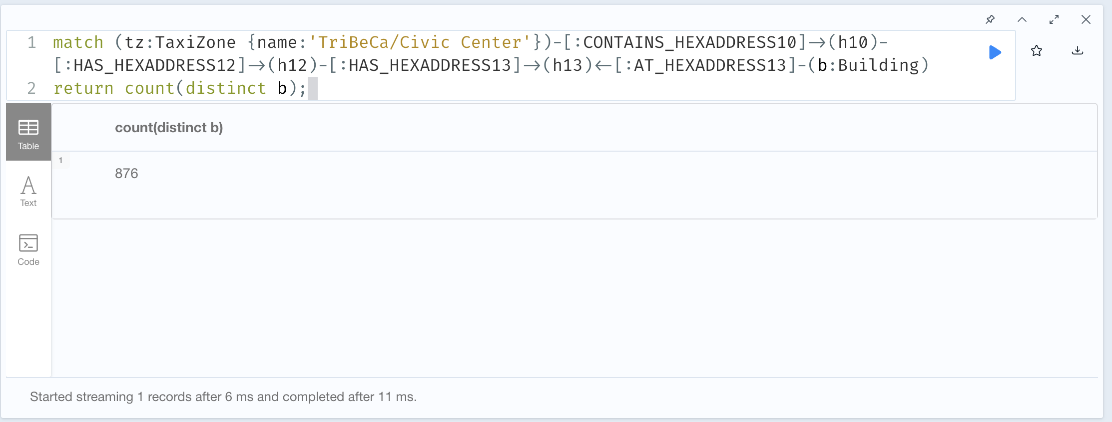
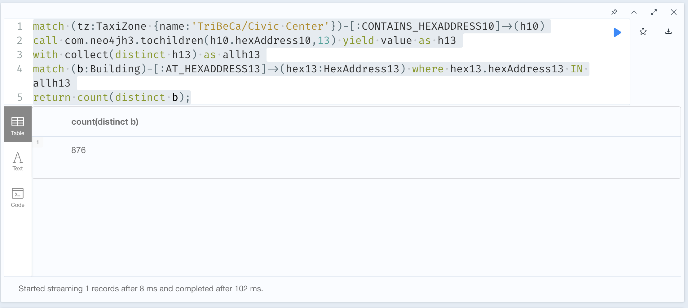
We can also use the com.neo4jh3.tochildren(h10.hexAddress10,13) procedure to calculate all of the children H3 addresses at resolution 13 and then query the buildings that would be in that collection of addresses. The query looks like this:
match (tz:TaxiZone {name:'TriBeCa/Civic Center'})-[:CONTAINS_HEXADDRESS10]->(h10)
call com.neo4jh3.tochildren(h10.hexAddress10,13) yield value as h13
with collect(distinct h13) as allh13
match (b:Building)-[:AT_HEXADDRESS13]->(hex13:HexAddress13) where hex13.hexAddress13 IN allh13
return count(distinct b);
This runs a little bit slower than the previous example but still gives the same results.
Finally, let’s see what buildings might be near a Point of Interest. We use the com.neo4jh3.toparent function to get the Point of Interest Hex address at resolution 13. Then we use the com.neo4jh3.gridDisk procedure to expand our search radius. Finally, we use the Neo4j point.distance calculation to return the distance in kilometers between the point of interest and the buildings.
match (p:PointOfInterest {name:'Little Chef Little Café'})-[:AT_HEXADDRESS14]->(ha:HexAddress14)
with p,ha
with p, com.neo4jh3.toparent(ha.hexAddress14,13) as h13
call com.neo4jh3.gridDisk(h13,10) yield value as h13rings
with p, collect(h13rings) as h13set
match (b:Building)-[:AT_HEXADDRESS13]->(bh13:HexAddress13)
where bh13.hexAddress13 in h13set
return p.name, b.bin, point.distance(point({latitude:p.latitude, longitude:p.longitude}),point({latitude:b.latitude, longitude:b.longitude}))/1000 as distance
order by distance asc;
Wrap-Up
We have walked through using our Geospatial Graph to identify objects within another polygon (i.e. Borough) or near one another without doing complex geospatial joins.
You may be thinking where are the trips or the NYC311 calls or even the NPI providers. Rather than add all of that data into this graph, we are going to have separate graphs for each data set and use the composite database feature to query them. Stay tuned for that upcoming post.